For a technology that has improved so many lives, you must be curious about how a GPS works.
You can look at GPS as the whole tracking system or individual devices. They work together to provide crucial location data for many apps and devices.
GPS works by transmitting satellite data to a GPS receiver, constantly receiving signals.
The receiver calculates the distance between itself and at least four satellites to provide a super accurate position through trilateration.
Due to the high speed at which satellites travel, atomic clocks are adjusted to minimize error margins and maintain positional accuracy even when desynchronized.
We’ll explore what GPS is, how it works step-by-step, and how GPS works to contribute to daily practical uses.
GPS Explained
To many users, GPS is that technology in their smartphone that helps them find locations and get precise traveling routes.
They’re right. But GPS is an intricate system of satellites, ground architecture, and receiver devices.
The U.S. Armed Forces developed GPS specifically for weapon target accuracy. Although it successfully reduced collateral, the developers saw extra utility in it.
They released a civilian version for positioning, navigation, and timing(PNT). Therefore, GPS became the gold standard for such systems.
Three levels determine how GPS works step by step. The three levels run 24 hours daily to provide accurate data at any time.
The Space Level
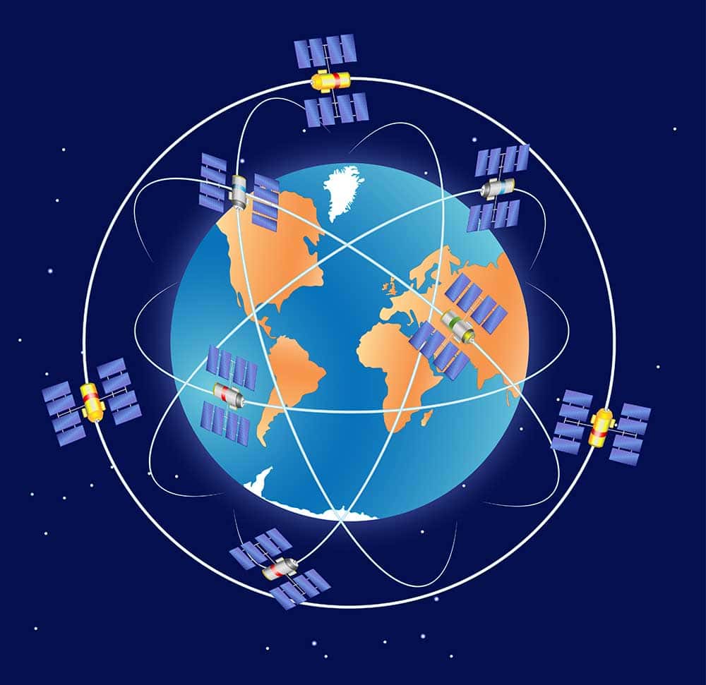
The GPS space segment hosts a constellation of 32 satellites 12,500 miles or 20,000 km above Earth. These GPS satellites incline specifically at a 55-degree angle.
They lie on six orbital planes, completing one trip around the globe every 11 hours and 58 minutes.
These six orbital planes are vital for positional accuracy since exact coordinates need at least four satellites to be visible. Each of these satellites is equipped with different signal frequencies.
GPS satellites emit L1 and L5 for free public use. However, due to the satellite’s Earth-to-Space distance and obstructions, it is common to get weak signal patterns.
The Control Level
The control or ground segment is the midpoint between space and your device. The ground level hosts three stations: data uploading, master control, and monitor stations.
The data uploading station only sends signals to the satellites. However, it also receives data from the master control station.
The master control communicates with the upload center and monitor station. They also only receive signals from the satellites.
However, they don’t directly send signals to the satellites.
Finally, monitor stations receive satellite data and relay the information to the master control.
The ground/control level hosts atomic clocks for calculating speeds and time. These calculations maintain the accuracy of relayed data.
Ground stations and their backups, ground antennas, and monitoring centers exist in many locations worldwide to ensure global positioning is correct everywhere.
The User Level

Driver using GPS-enabled smartphone to find a route
Think of any device that can transmit location data. Smartphones, wearable tech, vehicle systems, and independent location devices are all part of the GPS user segment.
These devices receive signals and relay data to satellites and a section of the ground level.
They form the most vital part of the GPS since they give exact locations of where they are.
GPS receivers can work out distances, time, speed, and positions.
Given all three levels of GPS, how does it work?
How GPS Works
Imagine you are on a flat plane. Your GPS receiver beams a signal to the GPS satellite.
The satellite will receive the time the signal went out and calculate the location according to the distance between itself and the receiver.
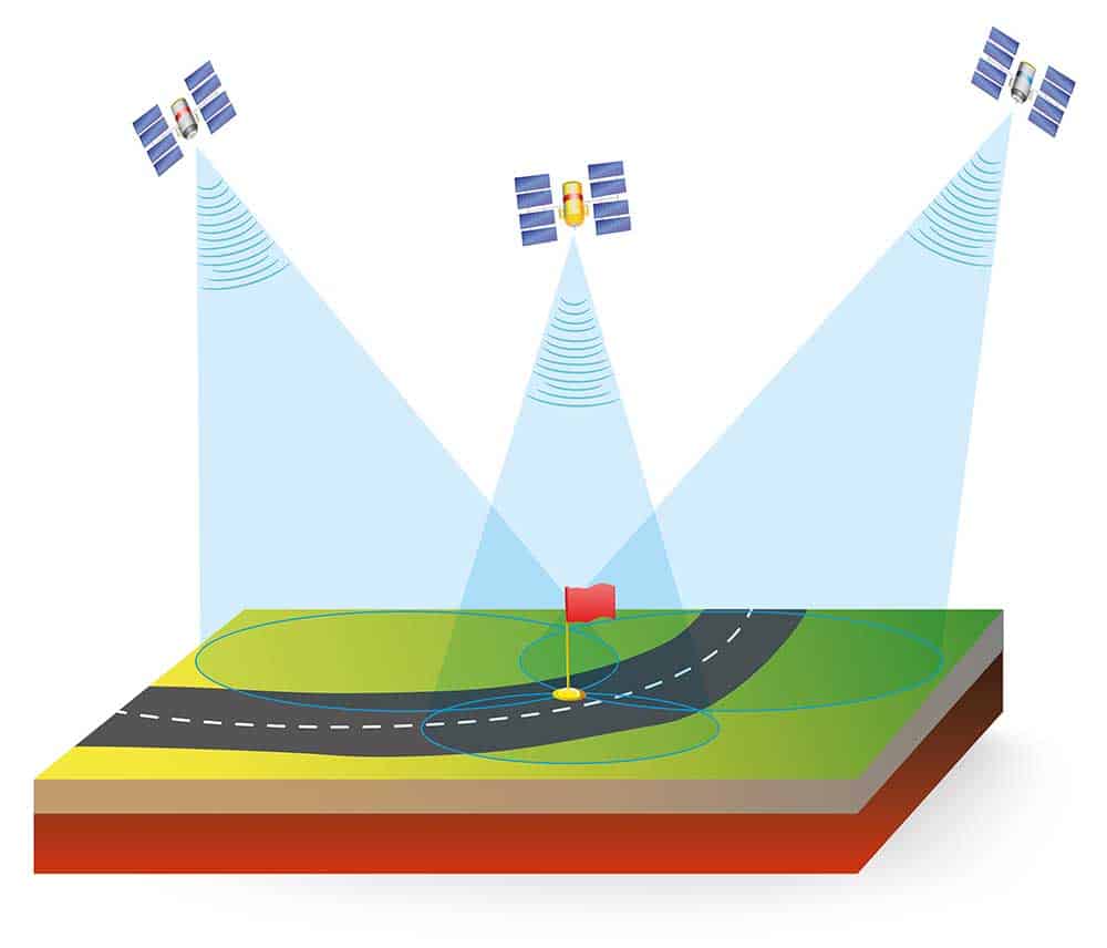
Three satellites and a precise GPS receiver location
However, that location could be miles off since satellites move exceptionally fast, and the circumference of the complete revolution is too large.
If you add another satellite, you narrow the GPS receiver’s location down to two locations. The receiver can only be on the two points where the satellites meet.
Therefore, it takes three satellites to transmit speed, location, and distance data to accurately approximate the GPS receiver’s location.
Again, while three satellites give a better position, the location could be far from where the receiver is. On a 2D plane, trilateration gives us the GPS receiver’s location as the intersection point of the three satellites.
Remember, civilian GPS needs to be accurate to the nearest detail. Therefore, at least four satellites must be visible to the GPS receiver.
The receiver tracks and identifies the four satellites and calculates speed, distance, and current satellite position.
These four satellites on different planes provide locations in four different values. Using all four satellites, the GPS receiver can place your latitude, longitude, altitude, and time.
Your position is now visible to the nearest detail on a 3D plane.
GPS Signals and Frequencies
As we mentioned, GPS operates using signals in different frequencies.
The military uses the M-code. The M-code signal prevents protection against jamming.
While it travels through L1 and L2 signals, it does not interfere with them. Instead, it makes them more iron-clad and less vulnerable to interference.
GPS satellites broadcast in the 1575.42 MHz L1, 1227.60 MHz L2, and 1176.45 MHz L5 frequencies.
The only problem is that the L1 and L2 can’t travel for long distances without interference.
Therefore, GPS receivers can get incorrect location data due to a large margin of error.
On the other hand, the L5 for civilian use is much stronger. Additionally, new frequencies 1227.60 MHz L2 and L1C are in the pipeline. These new frequencies are reserved for civilian use.
What Affects GPS Signal Accuracy?
The second layer of GPS, the ground/control level, is responsible for keeping GPS data as accurate as possible.
However, satellite speed and atmospheric interruptions can give wildly incorrect location data.
Therefore, the ground segment of the GPS houses stations that correct any miscalculation.
Here are the factors that contribute to GPS accuracy errors.
Clock Errors in GPS Devices
The GPS device and satellite clocks must be synchronized to minimize error. Here’s how to look at it. The signal travels at 300,0000 kilometers per second. A 1-microsecond error could set off a distance error of 300 meters.
Atomic clocks in the ground segments are adjusted to nanoseconds. Therefore, the margin of error is reduced to 30 centimeters per nanosecond of time difference.
Furthermore, the satellite’s and ground station’s atomic clock are synchronized to reduce the margin of error.
Visible Satellite Count
Multiple GPS satellites orbiting Earth
GPS has 32 satellites in orbit at any time. With six orbital planes, the more satellites the GPS receiver can ‘see,’ the more accurate the final position will be.
It moves positional data from just one metric to four different points.
Signal Path
GPS satellites are already deep in space. Therefore, the signal is bound to weaken as it hits physical impediments to GPS receivers. Walls, rocks, and buildings all deteriorate GPS satellite signals.
And that’s why GPS III will transmit L5 signals that can travel better through physical obstructions.
Signal Speed Through Ionosphere and Troposphere
Slight delays as GPS signal moves through the atmosphere can significantly affect the final positioning of the receiver.
Ground-level stations correct these delays by constantly availing more satellites and improving accuracy.
Error in Satellite Orbital Position
Incorrect satellite positions create errors in the calculation of receiver-to-satellite distance.
Therefore, the GPS receiver gets an inaccurate reading, which could lead to directional deviation and wild location inaccuracy.
Fortunately, receivers don’t rely on a set number of satellites.
Conclusion
GPS has come a long way from when it was first developed. It is becoming more detailed and updated to give pinpoint location accuracy.
The satellites and supporting stations continuously get upgrades that make GPS signals less vulnerable to weakening and interference.